Showing posts with label Responsive. Show all posts

OUGD503 - Responsive: P.A. Kelsall Research

I looked at existing websites for plumbers to see what tone of voice people have used, and how I could use more content.

I looked at bathstore.com as it is related to plumbing to see how they have laid out their information. It's a bigger site than what I thought it would be, but it is straightforward and functional.


I then started looking at plumber's websites, and I didn't see a single well designed one.
But, it was useful for me to see what content was on the sites. This is because I got little content given to me, and I felt like I needed more to fill out space. So it was useful for me to see what plumbers had on their sites.
I think people expect plumbing sites to look like this as it isn't exactly a priority for them to look good, because this doesn't affect whether they use their service or not.
So I think that when designing mine I should keep it simple, functional and straightforward, but obviously well designed still.


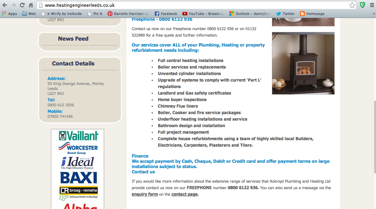
Another site for plumbing and heating, which is what my client labels himself as. They all seem to have a blue colour scheme with a hint of red to show the heating part of their job. I think this is quite tacky, and the colours chosen don't really go. 
I don't like this website because it looks cheap. This is because of the tacky stock image, the images on the logo and just the overall layout of it.


But it does have here what services it uses, which is handy for me because I want to include a services section on the website, so I can look at the kind of content here for the sake of showing the client what I mean.


Another site shows the services and why you should choose them. I've taken note of this because I can get some ideas for the content.


OUGD503 - Responsive: Matthew Savage Photography

This is all the research I did for this brief. I didn't really look at any portfolio websites as I didn't want to get influenced by them, as they are all pretty similar.

Jon Wyatt
The client told me a photographer's website that he liked, regarding the monochrome and clean style as well as the navigation. I had a look to see the sort of style that he wanted to go for. The navigation is actually pretty hard to use because it is at the bottom of the page, so hard to see, and has a fading feature when you hover over it. This brings up the sub navigation. I like to see the albums on a portfolio website so you can visually choose what you want to look at, but you don't have that option here.


I find the images awkwardly placed in the middle of the page.


At the bottom of the images on the album pages you can hover over the pagination to see what pictures there are which is helpful for the user.


This is what the navigation looks like. It's unfamiliar to the user because it's at the bottom.


Aside from being hard to use, I understand the style - clean, minimal and monochrome. I can work with that.

I wanted to create SVG for the site, which are scalable vector graphics. This means they can be scaled at any size and not pixelate, which is what are used on responsive sites. I didn't know how to do it, so I googled it. Turns out it's really easy, all you do is save a file to the format .svg. 


 Paul Boekhout
I wanted to see how other people used portrait and landscape images together, so I looked at this website.
There is one image per screen, so black has been used on the sides of portrait images. This is something I considered but didn't know if people did it because it could look messy. However, it is done here what is considered to be a good design, so I feel better about it now. I do think it is better if there is no gap between images, but this is something I can talk to my client about.


Facebook Vector
I wanted a Facebook icon vector to link to his facebook page, so I found a free vector pack that I could download.


OUGD503 - Responsive: BEAR - Further Research/Bodycopy

When designing the packs we decided we needed more specific research, particularly on the Rivers box.
I also started writing the bodycopy


I started writing down more facts:

River Facts

Bear

8 species of bears

During the Winter, bears go into a deep sleep called Hibernation. They wake up again in Spring. They don't need to eat or drink. They do this because there is no food in Winter

Incredible sense of smell

Brown bears can give birth during hibernation

Bears have two layers of fur - a long layer to keep water away from the short fur and skin, and a short layer to keep the bear warm

Black bears, grizzly bears

Lake

Caspien lake is largest in the world
Great lakes of America, michigan, superior 

Finland has 187,000 lakes Land of the Thousand Lakes

Salmon

Salmon can be found in Atlantic and Pacific oceans as well as inland lakes like the Great Lakes

Salmon migrate to the Pacific ocean - how far do they travel? 
Some go as far as Japan before coming back to the river they were both.

Salmon are born in rivers, and then swim into the sea where they live most of their adult life. They then come back to the rivers they were born which is called the salmon run and they jump.

They can feel what season it is, and swim back to where they were born even after travelling for years and thousands of miles into the sea.

They can find the right stream to spawn (lay eggs) just by the smell of it

During the salmon run, they swim back to the river they were born, jumping over waterfalls. The highest recorded jump is 12ft!

Camping

Deer
They are the largest land mammal in England.
They can jump nearly 10ft - that's as many as ten of these cereal boxes!

Rabbit
They thump loudly on the ground if they get scared to let other rabbits know!
When they are happy they 'binky' - where they jump and hop around!
Some females can have up to 8 litters in one year!
Rabbits teeth never stop growing throughout its life!

Treetops

Tree Stump
You can tell how old a tree is by counting its rings! 

You can count how old a tree is, by how many rings it has!
1 ring = 1 year !

Squirrel
Grey Squirrels are quite the gardeners, planting thousands of trees a year by forgetting where they buried 74% of their acorns!

Owl
The Great Horned Owl gets its name from the tufts of feathers on their head - they look like horns!

Woodpecker
Despite pecking up to 12,000 times a day, woodpeckers don't get headaches!

Red Crossbill
The female Red Crossbill is actually yellow!

Tree 1
Big Tree Facts : The tallest tree in the world today is a Giant Sequoia named General Sherman - he's 275ft tall!
Tree 2
Big Tree Facts: A famous Oak Tree called Major Oak served as a shelter for Robin Hood and his merry men in Sherwood Forest. It has a waistline of 33ft!

Instructions

Instructions
Build your own table-top treetop!

Using a pair of scissors to… 

Fold/Cut

Always make sure you have adult supervision!

Mountains

Moose
Males are immediately recognizable by their huge antlers, which can spread 6 feet (1.8 meters) from end to end.

Eagle
The American Bald Eagle isn't actually bald.

Marmots
The marmot hibernates for up to nine months a year, and loses 20 percent of it's body fat in this time.

OUGD503 - Responsive: BEAR Lakes Research

We decided to get rid of 'woodland' as a theme for one of the cereal boxes as we feared it wouldn't be very exciting with just animals and shrubbery. So, we decided to go with lakes, as we can do a lot with that - canoes, lake, animals etc.


OUGD503 - Responsive: Collaborative - BEAR Rivers Research

I started looking at rivers for my final bit of research as we want to include these on one of the backs of cereal.

I started looking at Yellowstone River, as we have already looked at Yellowstone together as a source of inspiration for the woodland.

I'm going to highlight the parts of text that I could use.

Yellowstone River

The Yellowstone River (Assiniboineȟeȟága wakpá, įǧų́ǧa wakpá, į́yąǧi wákpa [5]) is a tributary of the Missouri River, approximately 692 miles (1,114 km) long, in the western United States. Considered the principal tributary of the upper Missouri, the river and its tributaries drain a wide area stretching from the Rocky Mountains in the vicinity of the Yellowstone National Parkacross the mountains and high plains of southern Montana and northern Wyoming.

The river rises in northwestern Wyoming in the Absaroka Range, on the Continental Divide in southwestern Park County. The river starts where the North Fork and the South Fork of the Yellowstone River converge. The North Fork, the larger of the two forks, flows from Younts Peak. The South Fork flows from the southern slopes of Thorofare Mountain. The Yellowstone River flows northward through Yellowstone National Park, feeding and draining Yellowstone Lake, then dropping over the Upper and LowerYellowstone Falls at the head of the Grand Canyon of the Yellowstone within the confines of the park. After passing through theBlack Canyon of the Yellowstone downstream of the Grand Canyon, the river flows northward into Montana between the northern Absaroka Range and the Gallatin Range in Paradise Valley. The river emerges from the mountains near the town of Livingston, where it turns eastward and northeastward, flowing across the northern Great Plains past the city of Billings.
East of Billings, it is joined by the Bighorn River. Further downriver, it is joined by the Tongue near Miles City, and then by thePowder in eastern Montana. It flows into the Missouri River near Buford, North Dakota just upstream from Lake Sakakawea.
In Montana the river has been used extensively for irrigation since the 1860s. In its upper reaches, within Yellowstone Park and the mountains of Montana, it is a popular destination for fly fishing. The Yellowstone is a Class I river from the Yellowstone National Park boundary to the North Dakota border for the purposes of stream access for recreational purposes.[6]
The division of water rights to the entire Yellowstone River Basin among Wyoming, Montana and North Dakota, governed by a 1950 compact, was disputed in a 2010 lawsuit brought directly in the U.S. Supreme Court by Montana against Wyoming. Oral argument took place in January 2011. On May 2, 2011, the Court held 7-1 (by Justice Thomas, with Justice Scalia dissenting) that Montana had no valid claim for diminution of its water, since Wyoming was irrigating the same acreage as always, albeit by a more modern method that returned less runoff to go downstream to Montana.[7] (A subsequent 2011 Supreme Court case, in which Montana asserted ownership of Missouri Basin riverbottoms, so as to collect decades of back rent from a hydropower company, is unrelated. On February 22, 2012, Montana lost that case too.)


Longest Rivers
I then looked at the biggest rivers in the World.


This table gives a bit more information, saying where they are in the world.


Facts
I looked at a site for river facts for kids

  • The longest river in the world is the Nile River, it reaches around 6650 kilometers in length (4132 miles). More Nile River facts.
  • The second longest river in the world is the Amazon River, it reaches around 6400 kilometres in length (4000 miles). More Amazon River facts.
  • The longest river in the USA is the Missouri River, stretching around 2,340 miles (3,770 km) in length (slightly longer than the Mississippi River). The two combine to form the longest river system in North America, reaching around 3902 miles in length (6275 km). More Mississippi River facts.
  • Small rivers often have different names which include creek, stream and brook.
  • Rivers normally contain freshwater.
  • The word upriver (or upstream) refers to the direction of the river’s water source, while downriver (or downstream) refers to the direction in which the water flows, i.e. towards the end of the river.
  • Rivers have many uses which include fishing, bathing, transport, rafting and swimming among others.
  • Most of the world’s major cities are located near the banks of rivers.
  • The Ganges, Yangtze and Indus rivers are three of the most polluted on Earth.
  • The University Boat Race is held every year on the Thames River in London between the Oxford University Boat Club and the Cambridge University Boat Club. The crews feature eight members who battle it out on the 6,779 m (4 miles and 374 yards) course.
  • The Colorado River travels through the south western United States and north western Mexico, it is home to the famous Hoover Dam.
  • On January 15 2009, a US Airways plane successfully made an emergency landing in the Hudson River that runs through New York. After being hit by birds, the pilot of flight 1549 managed to land the plane in the river with the loss of no lives.

I then looked at amazon facts from the link in these facts.

  • The Amazon River is located in South America. It runs through Guyana, Ecuador, Venezuela, Bolivia, Brazil, Colombia and Peru.
  • The length of the Amazon River is approximately 6400 kilometres (4000 miles).
  • During the wet season, the Amazon River can reach over 190 kilometres (120 miles) in width.
  • There are no bridges that cross the Amazon, mostly because there is no need, the majority of the Amazon River runs through rainforests rather than roads or cities.
  • The largest city along the Amazon River is Manaus. Located in Brazil it is home to over 1.7 million people.
  • There are over 3000 known species of fish that live in the Amazon River, with more constantly being discovered.
  • Anacondas lurk in the shallow waters of the Amazon Basin, they are one of the largest snakes in the world and occasionally attack larger animals such as goats that get to close the water.
  • The Amazon River is also home to the piranha, a meat eating type of fish! Being carnivores, piranhas are known to attack in groups, preying on livestock that strays into the water and possibly appearing in one or two of your own nightmares!
  • Want to know more about the Amazon? Check out our Amazon rainforest facts.

I then looked at the Mississippi river facts

  • The length of the Mississippi River is approximately 2,320 miles (3,730 km), slightly shorter than the Missouri River.
  • The Mississippi and Missouri Rivers combine to form the longest river system in the USA and North America. It is also the fourth longest in the world.
  • At its widest point, the Mississippi River stretches out over 7 miles (11 km) in width.
  • The Mississippi River lies in the following ten US states: Louisiana, Mississippi, Arkansas, Tennessee, Kentucky, Missouri, Illinois, Iowa, Wisconsin and Minnesota.
  • The Mississippi River has had strong historical significance in the USA from Native American tribes through to European explorers, the American Civil War, the Great Mississippi Flood of 1927 and its modern commercial uses.
  • The first bridge built across the Mississippi River was in 1855 with the first railroad bridge finished a year later in 1856.
  • Martin Strel, a Slovenian swimmer who is famous for swimming the length of entire rivers conquered the Mississippi over 68 days in 2002.
  • Many of Mark Twain’s famous stories are related to or take place near the Mississippi River, this includes the well known ‘Adventures of Huckleberry Finn’.
I then looked at the River Nile facts

  • The length of the Nile River is approximately 6650 kilometres (4132 miles). It is believed to be the longest river in the world.
  • Located in Africa, the Nile River lies in the following countries: Kenya, Eritrea, Congo, Burundi, Uganda, Tanzania, Rwanda, Egypt, Sudan and Ethiopia.
  • The Nile River has huge significance in regards to Ancient Egypt. Most of Ancient Egypt’s historical sites are located along the banks of the Nile River including cities such as Luxor and Cairo.
  • In 2004, the White Nile Expedition became the first to navigate the entire length of the Nile River. The expedition began in Uganda and finished in Rosetta, taking four months and two weeks to complete.
  • The Nile Delta in Northern Egypt is where the Nile River drains in to the Mediterranean Sea. It is around 160 kilometres (100 miles) in length and spreads out over 240 kilometres (149 miles) of coastline. It is rich in agriculture and has been farmed for thousands of years.
  • Around 40 million people (half of Egypt’s population) live in the Nile Delta region.
  • In 1787, the famous Rosetta stone was found in the Nile Delta in the city of Rosetta. This Ancient Egyptian artifact played a key role in modern understanding of Egyptian hieroglyphics.
  • The Aswan High Dam was built in 1970 to help regulate flooding of the Nile River. Before the Aswan Dam was built, years that featured high levels of water could wipe out crops while years of low level water could produce famines and drought. The dam helps control these water levels.

River Nile


Amazon


Great Mississippi Flood of 1927


Mouth of the Amazon River


OUGD503 - Responsive: Collaborative - BEAR Mountains Research

I started looking at mountains for one of the areas we are looking at on the back of our packs.

Tallest Mountains


Rocky Mountains

Topography

While the Rocky Mountains sit high above sea level, hitting the 14,000-foot range in most areas, the mountains themselves are not particularly high since they rise from areas already at 4,000 to 8,000 feet above sea level. Mount Elbert near Leadville, Colorado, has an elevation of 14,433 feet, making it the tallest peak in the mountain range. The popular Pikes Peak, the second most visited peak in the world, is only the 31st highest, rising 14,110 feet above sea level. Peak Bagger indicates that the Rockies are fairly gentle and require little technical mountaineering to climb, with the summit of Mount Elbert reachable by bicycle.

Animal Life

Because the Rocky Mountain Range covers such a vast geographical area, the animals found in the mountains vary from location to location. The National Park Service indicates that Rocky Mountain National Park serves as the habitat to 66 mammal species, including the rare lynx and wolverine. Above the tree line, small pikas live in the rocky crevices of the mountains. Black bears, coyotes, elk, marmots, mountain lions, bighorn sheep and moose also live in Rocky Mountain National Park. Banff National Park in Canada has numerous bighorn sheep as well as hoary marmots, grizzly and black bears and the golden mantled ground squirrel, among other creatures.

Length

The Rocky Mountain Range actually represents a series of more than 100 separate mountain ranges, rather than one uninterrupted mountain chain. These ranges stretch through New Mexico, Idaho, Montana, Wyoming, Utah and Colorado, and also extend into British Columbia and Alberta, Canada. The entire series of mountain ranges measures approximately 3,000 miles.

Boundaries

The southern edge of the range sits in central New Mexico, with the Liard River in Canada serving as the northern boundary. On the east, I-25 serves as the boundary in the US. The Rocky Mountain Trench serves as the western edge in Canada. The western edge in the United States is not well defined, as the mountains gradually merge into the Great Basin desert regions.

National Parks

Because of the vast expanse covered by the Rocky Mountain Range, it holds several national parks. On the Canadian side, Banff, Kootenay, Yoho and Jasper National Parks protect the landscape and wildlife of the Rocky Mountains. Canada also has three provincial parks, Mount Robson, Mount Assiniboine and Hamber, along the Rockies. On the US side, the Rocky Mountain National Park, Yellowstone National Park, Grand Teton National Park, Glacier National Park and the Royal Gorge Park, among others, all give guests the opportunity to explore the Rockies.

Blue Planet

The Rocky Mountains are located in western North America. They are know for their beautiful scenery with mountains, trees and big game. People visit the Rockies for many recreational activities like hiking, hunting, camping, skiing and lots of other sports.
The Rocky Mountains have unpredictable weather which can change rapidly. As with other highland climates, the climate changes with increasing altitude. In general, the Rockies have mild summers, cold winters and a lot of precipitation.
The Rockies have very different seasons. In the winter there is deep snow, high winds, and sudden blizzards are common. At night it can get to -35û F or below! In the spring there is unpredictable weather. It could be wet or dry, cold or warm. In the summer there are sunny mornings, afternoon thunderstorms and clear nights. In the fall there are cool, crisp days, wind and decreasing precipitation.
There is lots of vegetation. The forests are full of pine trees, firs and spruces.Plants are very sturdy, most clinging to rock or hard soil.
Some adaptions that animals have made to the climate is that the hoofed species are very surefooted for the mountainous terrain they live on. Many animals migrate to lower and warmer elevations during the winter months. Some animals shed their brown fur to replace it with white so that they blend in with the snow. Some hibernate and some even have big feet so that they can walk on snow.
Koppen's letter code that describes the Rockies are H, Csb and Cfc. H means highland climate. C means warm temperature climate. s means dry season in summer. f means sufficient precipitation in all months. b means warmest month mean under 71.6û F. c means fewer than four months with means over 50û F.
The average temperature per year is 43û F. For Winter the average temperature is 28û F. 40û F is the average Spring temperature. In the Summer 59û F is the average temperature and for Fall it is 44û F. The highest temperature is 82û F in July. The lowest temperature is 7û F in January.
The average precipitation per year is 14 inches. The average for winter is 1.4 inches. The average precipitation for the season of spring is 4.2 inches. For summer it is 5.9 inches and for fall it is 2.6 inches. In the winter there are some snowstorms and blizzards. It snows later in the fall and there is decreasing precipitation. There is a lot of thunder and lighting in the summer. It rains and snows in the spring.
The latitude and longitude range is 35û N to 60û N, and 115û E to 165û E.
The Rocky Mountains are rich in environmental treasures. Conservation and protection is important to make sure the Rockies are just as wonderful as they are today for many generations.
by Hilary D. 2003


Himalayas


Himalayas, Nepali Himalaya,  great mountain system of Asia forming a barrier between the Plateau of Tibet to the north and the alluvial plains of the Indian subcontinent to the south. The Himalayas include the highest mountains in the world, with more than 110 peaks rising to elevations of 24,000 feet (7,300 metres) or more above sea level. One of these peaks is Mount Everest (Tibetan: Chomolungma; Chinese: Qomolangma Feng; Nepali: Sagarmatha), the world’s highest, with an elevation of 29,035 feet (8,850 metres; seeResearcher’s Note: Height of Mount Everest. The mountains’ high peaks rise into the zone of perpetual snow.

Physical features

The most characteristic features of the Himalayas are their soaring heights, steep-sided jagged peaks, valley and alpine glaciers often of stupendous size, topography deeply cut by erosion, seemingly unfathomable river gorges, complex geologic structure, and series of elevational belts (or zones) that display different ecological associations of flora, fauna, and climate. Viewed from the south, the Himalayas appear as a gigantic crescent with the main axis rising above the snow line, where snowfields, alpine glaciers, and avalanches all feed lower-valley glaciers that in turn constitute the sources of most of the Himalayan rivers. The greater part of the Himalayas, however, lies below the snow line. The mountain-building process that created the range is still active. As the bedrock is lifted, considerable stream erosion and gigantic landslides occur.

Geography
  • Everest is 29,035 feet or 8848 meters high
  • The summit is the border of Nepal to the south and China or Tibet on the north
  • It is over 60 million years old
  • Everest was formed by the movement of the Indian tectonic plate pushing up and against the Asian plate
  • Everest grows by about a quarter of an inch (0.25") every year
  • It consist of different types of shale, limestone and marble
  • The rocky summit is covered with deep snow all year long
Weather
  • The Jet Stream sits on top of Everest almost all year long
  • The wind can blow over 200 mph
  • The temperature can be -80F
  • In mid May each year, the jet stream moves north causing the winds the calm and temperatures to warm enough for people to try to summit. This is called the 'summit window'. There is a similar period each fall in November.
  • It can be very hot with temperatures over 100F in the Western Cwm, an area climbers go through to reach the summit.
History
  • It was first identified by a British survey team in lead by Sir George Everest in 1841
  • Everest was first named Peak 15 and measured at 29,002 feet in 1856
  • In 1865, it was named Mount Everest, after Sir George Everest
  • In 1955, the height was adjusted to 29,028 feet and is still used by Nepal
  • China uses 29,015 feet as the official height today
  • Using GPS technology, the summit was measured at 29,035 feet in 1999
  • Everest is called Chomolungma in Tibet. It means mother goddess of the universe
  • Everest is called Sagarmatha in Nepal. It means goddess of the sky
Summits
  • The first attempt was in 1921 by a British expedition from the north (Tibet) side
  • The first summit team was a British expedition lead by Colonel John Hunt on the south (Nepal) side
  • The first summit was on May 29, 1953 by Sir Edmund Hillary from New Zealand and Tenzing Norgay, a Sherpa from Nepal. They climbed from the south side.
  • The first north side summit was on May 25, 1960 by Nawang Gombu (Tibetan) and Chinese climbers Chu Yin-Hau and Wang Fu-zhou
  • The first climbers to summit Everest without bottled oxygen were Italian Reinhold Messner with Peter Habler in 1978
  • The first woman to summit Everest was Junko Tabei of Japan in 1975
  • The oldest person to summit was Japanese Miura Yiuchiro, age 80 on May 23, 2013
  • The oldest woman to summit was Japanese Tamae Watanabe, age 73, in 2012 from the north
  • The youngest person to summit was American Jordan Romero, age 13, on May 23, 2010 from the north side
  • The youngest person to summit from the south side was Nepali Nima Chemji Sherpa on May 19, 2012
  • Apa Sherpa and Phurba Tashi both hold the record for most summits with 21, the most recent one in 2013
  • About 3,668 climbers have summited Everest once and another 2,540 have summited multiple times totaling 6,208 summits of Everest through June 2012
  • The Nepal side is more popular with 3877 summits compared to 2331 summits from the Tibet side
  • 363 women have summited through June 2012
  • 178 climbers summited without supplemental oxygen through June 2012, about 2.8%
  • 249 people (162 westerners and 87 Sherpas) have died on Everest from 1924 to 2013.
  • More people have died on the South side, 134 than on the Tibet side, 106.
  • Almost all are still on the mountain.
  • The top cause of death was from a fall, avalanche, exposure and altitude sickness
  • There were an estimated 600 summits in the Spring of 2013 bringing the total estimated summits to 6,800.
Climbing
  • There are 18 different climbing routes on Everest
  • It takes 40 days to climb Mt. Everest in order for the body to adjust to the high altitude
  • There is 66% less oxygen in each breath on the summit of Everest than at sea level
  • Thin nylon ropes are used to keep climbers from falling.
  • Climbers wear spikes on their boots called crampons
  • They also use ice axes to help stop a fall
  • Thick, puffy suits filled with goose feathers keep climbers warm
  • Most climbers eat a lot of rice and noodles for food
  • Almost all climbers use bottled oxygen because it is so high. It helps keep the climbers warm.
  • Climbers start using bottled oxygen at 26,000 feet but it only makes a 3,000 foot difference in how they feel so at 27,000 feet, they feel like they are at 24,000 feet
  • You have to be 16 or older to climb from the Nepal side and 18 on the Chinese side.
Sherpas
  • Sherpa is the name of a people. They mostly live in western Nepal. They migrated from Tibet over the last several hundred years
  • Sherpa is also used as a last name
  • Usually their first name is the day of the week they were born.
    • Nyima - Sunday
    • Dawa - Monday
    • Mingma - Tuesday
    • Lhakpa - Wednesday
    • Phurba - Thursday
    • Pasang - Friday
    • Pemba - Saturday
  • Sherpas help climbers by carrying tents and cooking food to the High Camps
  • Sherpas climb Everest as a job to support their families
  • Sherpas can get sick from the altitude like anyone
Trivia
  • Babu Chiri Sherpa spent the night on the summit in 1999
  • Over 33,000 feet of fixed rope is used each year to set the South Col route
  • You have to be at least 16 to climb Everest from the south side and 18 from the north
  • Climbers burn over 10,000 calories each day, double that on the summit climb
  • Climbers will lose 10 to 20 lbs during the expedition


Facts About Mt. Everest


  • Tallest mountain in the world. 
  • Number of people to attempt to climb Mt. Everest: approximately 4,000. 
  • Number of people to successfully climb Mt. Everest: 660. 
  • Number of people who have died trying to climb Mt. Everest: 142. 
  • Height: 29,028 feet, or 5 and a half miles above sea level. This is equivalent to the size of almost 20 Empire State Buildings.
  • Location: part of the Himalaya mountain range; straddles border of Nepal and Tibet.
  • Named for: Sir George Everest, a British surveyor-general of India.
  • Age: approximately 60 million years old.
  • Other names: called "Chomolungma" by Tibetans and Sherpas, which means "Mother Goddess of the Earth."
  • Countries visible from the summit: Tibet, India, and Nepal.
  • First to climb to summit: Edmund Hillary and Tenzing Norgay on May 29, 1953.
  • Notable dates:
    1921 — Dalai Lama allows British reconnaissance party to visit Tibet and the northern side of Mt. Everest.
    1924 — British explorers George Mallory and Andrew Irvine disappear near the summit, along the Northeast Ridge. It is possible that they may have actually been the first to reach the summit, but they never returned.
    1949 — Nepal opens its borders, making access to the mountain's southern peak possible.
    1953 — Hillary and Norgay reach summit.
    1963 — First Americans reach the summit.
    1989 — First two women, both American, reach the summit.
    1990 — Sir Edmund Hillary's son, Peter, reaches summit.
    1996 — Eleven people die during spring expeditions.


  • 28 The mountain is more than 28 times the height of the Shard.
    59 It is estimated that expeditions to climb the mountain take two months from start to end.
    60 Geologically speaking, Mt Everest is about 60 million years old.


    Aconcagua (Spanish pronunciation: [akoŋˈkaɣwa]) is the highest mountain in the Americas at 6,960.8 metres (22,837 ft).[1] It is located in the Andes mountain range, in the province ofMendozaArgentina, and lies 112 kilometres (70 mi) northwest of its capital, the city of Mendoza. The summit is also located about 5 kilometres from San Juan Province and 15 kilometres from the international border with Chile. Aconcagua is the highest peak in both the Western and Southern Hemispheres. It is one of the Seven Summits.
    Aconcagua is bounded by the Valle de las Vacas to the north and east and the Valle de los Horcones Inferior to the West and South. The mountain and its surroundings are part of theAconcagua Provincial Park. The mountain has a number of glaciers. The largest glacier is the Ventisquero Horcones Inferior at about 10 km long, which descends from the south face to about 3600 m altitude near the Confluencia camp.[3] Two other large glacier systems are the Ventisquero de las Vacas Sur and Glaciar Este/Ventisquero Relinchos system at about 5 km long. The most well-known is the north-eastern or Polish Glacier, as it is a common route of ascent.
    The mountain was created by the subduction of the Nazca Plate beneath the South American plate during the geologically recent Andean orogeny; but it is not an active volcano.[4] The origin of the name is contested; it is either from the Arauca Aconca-Hue, which refers to the Aconcagua River and means "comes from the other side",[citation needed] the Quechua Ackon Cahuak, meaning "'Sentinel of Stone",[citation needed] or Quechua Anco Cahuac, "White Sentinel"[5] or the Aymara Janq'u Q'awa, "White Ravine", "White Brook".[6]

    Yellowstone


    Yellowstone National Park, located primarily in the U.S. state of Wyoming, though the park also extends into Montana and Idaho and its Mountains and Mountain Ranges are part of theRocky Mountains. There are at least 70 named mountain peaks over 8,000 feet (2,400 m) in Yellowstone in four mountain ranges. Two of the ranges—The Washburn Range and the Red Mountains—are minor and completely enclosed within park boundaries. The other two ranges are major, multi-state ranges that extend far beyond the boundaries of the park. TheGallatin Range begins approximately 75 miles (121 km) north of Yellowstone near Bozeman, Montana and dominates the northwest corner of the park. The Absaroka Range, the largest range in the park, begins approximately 80 miles (130 km) miles north of the park near Livingston, Montana along the Yellowstone River and runs southeast into, then south through the entire eastern side of the park to the Wind River Range in Wyoming. The highest peak in the park, Eagle Peak is in the Absaroka Range. Yellowstone also has several isolated peaks over 8,000 feet (2,400 m) on the plateaus that dominate the central, western and southwestern sections of the park.[1]


    Wildfire is a natural part of most ecosystems, and plants found in Yellowstone have adapted in a variety of ways. Douglas-fir has a thick bark which protects the inner section of the tree from most fires. Lodgepole Pines —the most common tree species in the park— generally have cones that are only opened by the heat of fire. Their seeds are held in place by a tough resin, and fire assists in melting the resin, allowing the seeds to disperse. Fire clears out dead and down wood, providing fewer obstacles for lodgepole pines to flourish. Subalpine FirEngelmann Spruce,Whitebark Pine, and other species tend to grow in colder and moister areas, where fire is less likely to occur. Aspen trees sprout new growth from their roots, and even if a severe fire kills the tree above ground, the roots often survive unharmed because they are insulated from the heat by soil.[103] The National Park Service estimates that in natural conditions, grasslands in Yellowstone burned an average of every 20 to 25 years, while forests in the park would experience fire about every 300 years.[103]
    About thirty-five natural forest fires are ignited each year by lightning, while another six to ten are started by people— in most cases by accident. Yellowstone National Park has three fire lookout towers, each staffed by trained fire fighters. The easiest one to reach is atop Mount Washburn, though it is closed to the public. The park also monitors fire from the air and relies on visitor reports of smoke and/or flames.[104] Fire towers are staffed almost continuously from late June to mid-September— the primary fire season. Fires burn with the greatest intensity in the late afternoon and evening. Few fires burn more than 100 acres (40 ha), and the vast majority of fires reach only a little over an acre (0.5 ha) before they burn themselves out.[105] Fire management focuses on monitoring dead and down wood quantities, soil and tree moisture, and the weather, to determine those areas most vulnerable to fire should one ignite. Current policy is to suppress all human caused fires and to evaluate natural fires, examining the benefit or detriment they may pose on the ecosystem. If a fire is considered to be an immediate threat to people and structures, or will burn out of control, then fire suppression is performed.[106]

    Wildfire in Yellowstone National Park produces a pyrocumulus cloud
    In an effort to minimize the chances of out of control fires and threats to people and structures, park employees do more than just monitor the potential for fire. Controlled burns are prescribed fires which are deliberately started to remove dead timber under conditions which allow fire fighters an opportunity to carefully control where and how much wood is consumed. Natural fires are sometimes considered prescribed fires if they are left to burn. In Yellowstone, unlike some other parks, there have been very few fires deliberately started by employees as prescribed burns. However, over the last 30 years, over 300 natural fires have been allowed to burn naturally. In addition, fire fighters remove dead and down wood and other hazards from areas where they will be a potential fire threat to lives and property, reducing the chances of fire danger in these areas.[107] Fire monitors also regulate fire through educational services to the public and have been known to temporarily ban campfires from campgrounds during periods of high fire danger. The common notion in early United States land management policies was that all forest fires were bad. Fire was seen as a purely destructive force and there was little understanding that it was an integral part of the ecosystem. Consequently, until the 1970s, when a better understanding of wildfire was developed, all fires were suppressed. This led to an increase in dead and dying forests, which would later provide the fuel load for fires that would be much harder, and in some cases, impossible to control. Fire Management Plans were implemented, detailing that natural fires should be allowed to burn if they posed no immediate threat to lives and property.

    A crown fire approaches the Old Faithful complex on September 7, 1988.
    1988 started with a wet spring season although by summer, drought began moving in throughout the northern Rockies, creating the driest year on record to that point. Grasses and plants which grew well in the early summer from the abundant spring moisture produced plenty of grass, which soon turned to dry tinder. The National Park Service began firefighting efforts to keep the fires under control, but the extreme drought made suppression difficult. Between July 15 and 21, 1988, fires quickly spread from 8,500 acres (3,400 ha; 13.3 sq mi) throughout the entire Yellowstone region, which included areas outside the park, to 99,000 acres (40,000 ha; 155 sq mi) on the park land alone. By the end of the month, the fires were out of control. Large fires burned together, and on August 20, 1988, the single worst day of the fires, more than 150,000 acres (61,000 ha; 230 sq mi) were consumed. Seven large fires were responsible for 95% of the 793,000 acres (321,000 ha; 1,239 sq mi) that were burned over the next couple of months. A total of 25,000 firefighters and U.S. military forces participated in the suppression efforts, at a cost of 120 million dollars. By the time winter brought snow that helped extinguish the last flames, the fires had destroyed 67 structures and caused several million dollars in damage.[52] Though no civilian lives were lost, two personnel associated with the firefighting efforts were killed.
    Contrary to media reports and speculation at the time, the fires killed very few park animals— surveys indicated that only about 345 elk (of an estimated 40,000–50,000), 36 deer, 12 moose, 6 black bears, and 9 bison had perished. Changes in fire management policies were implemented by land management agencies throughout the United States, based on knowledge gained from the 1988 fires and the evaluation of scientists and experts from various fields. By 1992, Yellowstone had adopted a new fire management plan which observed stricter guidelines for the management of natural fires.[52]

    Recreation

    Yellowstone ranks among the most popular national parks in the United States. Since the mid-1960s, at least 2 million tourists have visited the park almost every year.[114] In 2010, a record number of visitors came to the park in July: 975,000. July is the busiest month for Yellowstone National Park.[115] At peak summer levels, 3,700 employees work for Yellowstone National Park concessionaires. Concessionaires manage nine hotels and lodges, with a total of 2,238 hotel rooms and cabins available. They also oversee gas stations, stores and most of the campgrounds. Another 800 employees work either permanently or seasonally for the National Park Service.[8]
    Park service roads lead to major features; however, road reconstruction has produced temporary road closures. Yellowstone is in the midst of a long term road reconstruction effort, which is hampered by a short repair season. In the winter, all roads aside from the one which enters from Gardiner, Montana, and extends to Cooke City, Montana, are closed to wheeled vehicles.[116] Park roads are closed to wheeled vehicles from early November to mid April, but some park roads remain closed until mid-May.[117] The park has 310 miles (500 km) of paved roads which can be accessed from five different entrances.[8] There is no public transportation available inside the park, but several tour companies can be contacted for guided motorized transport. In the winter, concessionaires operate guided snowmobile and snow coach tours, though their numbers and access are based on quotas established by the National Park Service.[118] Facilities in the Old Faithful, Canyon and Mammoth Hot Springs areas of the park are very busy during the summer months. Traffic jams created by road construction or by people observing wildlife can result in long delays.
    The National Park Service maintains 9 visitor centers and museums and is responsible for maintenance of historical structures and many of the other 2,000 buildings. These structures include National Historical Landmarks such as the Old Faithful Inn built from 1903 to 1904 and the entire Fort Yellowstone – Mammoth Hot Springs Historic District. An historical and educational tour is available at Fort Yellowstone which details the history of the National Park Service and the development of the park. Campfire programs, guided walks and other interpretive presentations are available at numerous locations in the summer, and on a limited basis during other seasons.
    Camping is available at a dozen campgrounds with more than 2,000 campsites.[8] Camping is also available in surrounding National Forests, as well as in Grand Teton National Park to the south. Backcountry campsites are accessible only by foot or by horseback and require a permit. There are 1,100 miles (1,800 km) of hiking trails available.[119] The park is not considered to be a good destination for mountaineering because of the instability of volcanic rock which predominates. Visitors with pets are required to keep them on a leash at all times and are limited to areas near roadways and in "frontcountry" zones such as drive in campgrounds.[120]Around thermal features, wooden and paved trails have been constructed to ensure visitor safety, and most of these areas are handicapped accessible. The National Park Service maintains a year round clinic at Mammoth Hot Springs and provides emergency services throughout the year.[121]
    Hunting is not permitted, though it is allowed in the surrounding national forests during open season. Fishing is a popular activity, and a Yellowstone Park fishing license is required to fish in park waters.[122] Many park waters are fly fishing only and all native fish species are catch and release only.[123] Boating is prohibited on rivers and creeks except for a 5 miles (8.0 km) stretch of the Lewis River between Lewis and Shoshone Lake, and it is open to non-motorized use only. Yellowstone Lake has a marina, and the lake is the most popular boating destination.[124]

    Vintage photo of visitors feeding bears in spite of the danger
    In the early history of the park, visitors were allowed, and sometimes even encouraged, to feed the bears. The bears had learned to beg for food, and visitors welcomed the chance to get their pictures taken with them. This led to numerous injuries to humans each year. In 1970, park officials changed their policy and started a vigorous program to educate the public on the dangers of close contact with bears, and to try to eliminate opportunities for bears to find food in campgrounds and trash collection areas. Although it has become more difficult to observe them in recent years, the number of human injuries and deaths has taken a significant drop and visitors are in less danger.[125]
    Other protected lands in the region include Caribou-TargheeGallatinCusterShoshone and Bridger-Teton National Forests. The National Park Service's John D. Rockefeller, Jr. Memorial Parkway is to the south and leads to Grand Teton National Park. The famed Beartooth Highway provides access from the northeast and has spectacular high altitude scenery. Nearby communities include West Yellowstone, Montana; Cody, Wyoming; Red Lodge, Montana; Ashton, Idaho; and Gardiner, Montana. The closest air transport is available by way of Bozeman, Montana; Billings, Montana; JacksonCody, Wyoming, or Idaho Falls, Idaho.[126] Salt Lake City, 320 miles (510 km) to the south, is the closest large metropolitan area.

    Yellowstone


    Beer hat 


    Andes


    Everest


    Mount McKinley


    Vinson Massif


    Aconcagua


    Copyright 2010. All rights reserved.

    RSS Feed. This blog is proudly powered by Blogger and uses Modern Clix, a theme by Rodrigo Galindez. Modern Clix blogger template by Introblogger.